West Hoathly
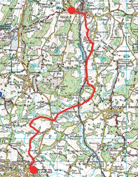
Walk 7 - West Hoathly to Lindfield
Distance: 6.5 miles / 10km
Grading: Moderate
Location: Explorer map 135 (Ashdown Forest)
Start point:
Finche Field Recreation Ground (car park),
Church Hill, West Hoathly RH19 4PN
End point:
Lindfield High Street, opposite The Tiger,
All Saints Church RH16 2HT
(The Wilderness Car Park RH16 2JE).
Please note: Sections of this walk, particularly the paths that go through farmyards, may be very muddy.
- From the car park (WAYMARKER 8), follow the footpath adjacent to the road that runs past the allotments. At the bottom of the steps, turn right by the pub and follow the pavement on the opposite side of the road along Top Road until you reach the Sharpthorne Club which is on the right, just past the Costcutter and Post Office.
- Turn right and then left at the end of the building, before the car park, to follow the footpath down an alley at the back of the clubhouse which continues on between two fences. At the end of this path there is a metal kissing gate, carry on across the field with the hedge to your left. Lovely views of the South Downs ahead.
- Head down the hill and at the bottom of the field continue through a metal gate into another field. Head straight across this field toward the metal gate at the bottom of the field.
- Walk down a steep bank and over a small stream to a stile and then turn right along the side of the stream. Head toward a large oak tree in the middle of the field, walk uphill and through another gate.
- Bear diagonally right across the field to the hedge on the other side, through a metal gate then walk through the field keeping the little fence to your left and head toward the trees. Turn right along the bottom edge of the field until you reach a gate, stile and fingerpost directing you to follow the Sussex Border
- The path goes between two fences and comes out onto a track by a house called Claverdale. Turn left and follow the track to a road where you need to turn right. The traffic is fast and there no pavement but there is a narrow grass verge on the right-hand side.
- When you reach the houses, turn right at Vox End down a track, the footpath turns to the left, go over a stile into a horse field. Walk straight through a couple of fields until you reach the Bluebell Railway.
- Don’t go over the bridge, cross the tarmac drive, over a stile and head South through a field with the railway line on your right until you reach a crossing. Stop, Look, Listen, over a stile, through a kissing gate over the tracks and turn left down the side of the track along the embankment which falls away quite steeply in places.
- When you reach a metal gate, turn right over the stile and follow the path through the woods, the path loops around back to the left, over the railway bridge, into a private car park and then turns to the
Resting Place (2 miles / 3 km): Bluebell Railway, Horsted Keynes Station RH17 7BB– stay on the track and walk down the hill to the entrance, if the station is open you can purchase a platform ticket and there is a café serving teas, coffees and snacks.
- From the car park, walk down the track, under the power line, and turn left (before the station) through a kissing gate onto a footpath with Leamland Wood on the right and a horse paddock on the left. Go over a stile into the field and follow the post and rail fence to the end then back over another stile and down a steep muddy path to reach the road.
- Go right at the road, there is no pavement so keep close to the hedgerow as the traffic is quite fast, pass Station Approach on your right and continue until you come to a house on the right hand side where there is a public footpath sign directing you down a track which leads to Oddynes Cottages.
- Go past Great Oddynes, a Georgian style house, and into a working farmyard. Go straight on keeping to the right hand track, continue straight on with farm buildings on both sides, then out through a five- bar metal gate. Keep going straight ahead, pass through two more metal gates, and you will reach a bridge over the Bluebell Railway.
Halfway Point: (3 miles / 5 km) Bluebell Railway Bridge, Nobles Wood
- Walk into the field, with Nobles Wood on your right, and go over a stile into the next field. Go straight on and down the hill, through a tight squeeze kissing gate, straight ahead toward a little bridge on your right that goes over a stream.
- The path goes off to the left, go through a high wooden gate and straight on uphill through a conifer plantation (not right), continue on through the next conifer plantation and at the top turn right, then go over a stile with a mesh gate into a wooded area which has lots of wild garlic growing in Spring.
- The narrow footpath runs along the top edge of the wood with a smallholding to your left. Turn right, on a plank bridge over a boggy patch, the path then heads left toward Goddenwick Farm where there is a pond on the left and field with a wooden animal shelter on the right.
- Follow the cement path with chestnut trees on either side and then turn left into a staked field and straight up through another conifer plantation. Follow the path around to the right toward the houses and over a stile.
- Turn left toward the main road, go straight across (taking great care because this is a fast road) to join a public footpath opposite which goes through some woods. Keep following the path through the woods until you come to a narrow path with trees on the right and a house on the left with a large beech hedge.
- Go past Burstye Farm on your right and then turn left to follow a tarmac track. Go past a large pond down on your right and just before a house a little further on turn right down a public footpath.
- Keep to the left-hand edge of a ploughed field, the path heads off from the corner of the field into a wooded copse and on to a bridge over the River Ouse. You will reach a field with a Beware of the Bull sign so cross swiftly and through a side gate into the farmhouse garden opposite. Keep right here as the ground near to the left hand fence can be particularly muddy.
- Keep the house on your right, go past the farm buildings and continue down the track ahead. Go through a metal kissing gate onto Spring Lane which leads to Lindfield High Street, turn right toward All Saints Church and turn left just before the Bent Arms into Dukes Road (WAYMARKER 1), then left again into the Wilderness for the car park.
If you prefer you can download the walk guide to your phone.
Walk 14 - West Hoathly Circular
Distance: 6.5 miles / 10.5km
Grading = Difficult (some steep hills)
Location: OS Explorer map 135 (Ashdown Forest)
Start/End point:
Finche Field Recreation Ground
(car park), Church Hill, West
Hoathly RH19 4PN

- Follow the path out of the car park toward the village (WAYMARKER 8) with the post and rail fence to your left and the road (Church Hill) below. Walk through the houses and at the end of Sandy Lane, turn left along North Lane past the Village Hall, the Cat Inn and St Margaret’s Church on your
- Follow the road around the corner past the Priest House Museum on the right and West Hoathly Bowls Club on the left and continue straight ahead on the broken-up tarmac track signposted Philpots Quarry and public bridleway that goes gradually downhill.
- The track goes past Philpots Manor School, it snakes right and then left, keeping to the right of farm buildings and stables, and goes down a steep slope into the woods. Continue on the main bridleway past some big clumps of bamboo and a hidden lake on the left-hand side, until you reach a road.
- Cross the road and follow the public bridleway ahead. The path goes uphill through the woods bearing left, keep the metal fence to your left and you will pass some large rock boulders on your right.
- The path comes out onto a track, turn right and then left to follow the public footpath sign down the Follow the footpath left down the hill and into the trees (not the bridleway that goes straight on), it goes quite steeply downhill to a wooden bridge over a little stream (it can be very muddy here) and continues on through the trees.
- At the top of the hill, where you come out of the woods, the path bears left signposted High Weald Landscape Trail. It goes straight through the field to a gate at the top. It is quite a steep hill and then the footpath narrows between a hedge on the left and a fence on the right until you reach Hook Lane, a quiet country road with no
- Turn right along the road past Ludwell House on your left and walk for a couple of minutes until you reach a footpath on the left-hand side with signposts to Pickeridge, Holly Farm. Follow the High Weald Landscape Trail along a track until you reach a footpath junction, take the left-hand fork past Old Holly Cottage, a wooden beamed building, and walk toward a barn ahead on the right.
- When you get to the barn the footpath is signposted off to the left, go over a stile and down the hill on the edge of the field with the hedge on your right. Go through a gap in the hedge into the next field and keep walking down.
- At the bottom, go over a stile and down some steep wooden steps through a wooded area that leads to a wooden bridge over a stream. On the other side, go through a gate into a field and go diagonally right up a very steep hill. At the top the path bears right onto a tarmac track which leads to a metal five bar gate and a farmyard. Go straight on past the farmhouse on the right and over a stile into Hammingden Lane where you need to turn left toward All Saints Highbrook Church
- Just before the church entrance turn right onto a public footpath, passing a renovated smokery with information board on your right (the door is usually unlocked if you want to stop here for a break), the footpath continues on a muddy track with a fence on the right and hedge to the left. Go through a five-bar gate into a field and down a very steep hill, keeping to the left-hand side of the field, with nice views to the South. Go through a gap in the hedge and continue on until you reach a gate and a stile, at the bottom of the field go through a five- bar gate and walk on through trees, with a steep gully on the left-hand side.
- You will reach a wooden bridge over a stream and then go up some wooden steps on the other side. Go over a stile and carry on into the field ahead, the path goes slightly left. At the top of the field go over a stile and continue on until you reach the Bluebell
- Stop, Look Listen! And cross over the line, then the path goes over a stile and turns left along the edge of the field. Over another stile to reach a brick bridge over the railway, cross the road and follow the narrow path straight ahead (can be very muddy).
- Go over a stile and go through the next field, over another stile then the path goes off to the right past a barn and a house until you reach Vox End and Horsted Lane where you need to turn left. There is no pavement but a wide grass verge, walk along the road past Saxons on the left and Violet Cottage on the right, until you reach a tarmac road on the left signposted public footpath toward Northwood House, Northwood Farm and Stablehurst.
- Go past Bromhall Cottage and then follow the public footpath sign to turn right through a gate and over a stile, go straight up the hill ahead along the left-hand edge of the field and then turn diagonally right toward a gate in the top right- hand corner.
- Turn slightly diagonally right through a field until you reach a metal gate into the next field where the path goes off downhill to the right. You will reach a stile, go over a stream and then through another metal gate. Go straight ahead across the field and there is another metal gate opposite.
- Keep going up the hill on the right-hand side of the field until you reach a kissing gate. Follow the track up the hill, the path leads to the back of the Sharpthorne Village Club where you need to turn left around the back of the building and out onto Top Road.
- Turn left here, by the Cost Cutter and Sharpthorne Village Garage, toward West Hoathly along the When you reach the junction by The Fox pub, turn to the left up some steps by the village noticeboard which leads back to the car park (WAYMARKER 8).
If you prefer you can download the walk guide to your phone.