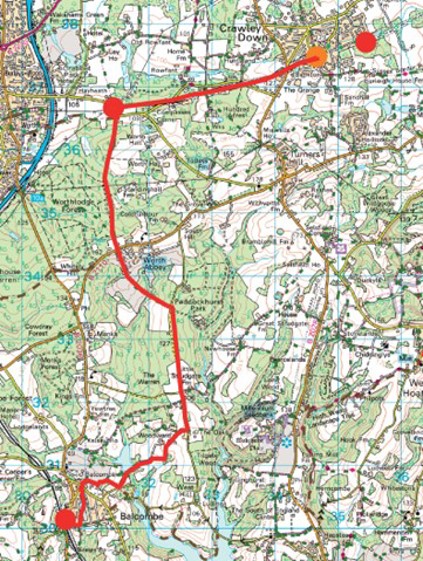
Balcombe
Walk 4 - Balcombe to Crawley Down
Distance: 7 miles / 11km
Grading: Easy
Location: OS Explorer map 135 (Ashdown Forest)
Start point:
Balcombe Railway Station (car park), London Road, Balcombe RH17 6JQ (reasonable daily charge)
End point:
Burleigh Way Car Park, Crawley Down RH10 4HJ
- From the station car park, take the pedestrian bridge, from the north bound platform, over the railway line and go up the steps to London Road. Turn left (WAYMARKER 4) and cross the road at the island. Take the path to the left of the red telephone box which leads to Newlands
- Cross over and turn right to walk along the pavement until you reach Jobes. Turn left and follow the public footpath on the right which leads to the recreation ground. Walk straight on past the bowls club until you reach Stockcroft
- Turn left, past Victory Hall, then go right toward the Half Moon Pub and Balcombe Village Stores. Go past the store and then turn right to follow the public footpath. The track bears right and goes toward Balcombe Cricket Club.
- When you reach the playing field, follow the footpath around to the left until you reach a small wood. A gate leads into another field, keep the hedge to your left and go straight on,then at the sign turn right downhill toward Balcombe
- Walk on past the lake to your left, up the tarmac path which eventually bears left. A red sign states that the drive beyond this is private and a detour is necessary to rejoin the drive on the other side of the farm. Take a sharp right through a gate and a stile into a field, keep along the top edge by the
- A gate and stile lead into the field on your left. Go up with the wood to your right but do not get to close to it. Head for another field the other side of a hedge toward a barn where the drive, now a track, is rejoined.
- Turn right through a gate and up the chalk track ahead to the top where another track comes in from your left. Turn right and follow this track to emerge on a narrow lane. Turn left and follow this lane (Back Lane) for about 1.25 miles.
- Continue to follow Back Lane, passing a lane (Stoney Lane) to the left and a drive to the right. There are initially fields on both sides of the lane, it then passes through a wood, then a large field on the left with a view of Worth Abbey.
- The route turns left along a footpath just as a wood starts on the left opposite a drive and white gate. Cross the stile next to the gate and follow the path downhill with the field on your left and a fence and woods on the right ignoring two tracks into the woods.
- At the bottom of the field the path enters a wood and crosses a stone bridge (or alternatively use the wooden plank bridge which crosses the stream to your right). Follow the track up with a field to your left and a wood to the right.
- Ignore the track off to your right and when the wood finishes; Worth Abbey can be seen to your right. There are tennis courts on the right and then the track becomes a paved road. Before you reach the impressive gates, continue straight on into a field which is used as a golf course. Keep the low wall to your right then bear left toward the busy road (B2110).
Halfway Point (3 miles / 5 km): Worth School, Worth Abbey, Paddockhurst Road, Turners Hill RH10 4SD
- Cross over the road withcare, turn right, then almost immediately left toward a large wooden gate to follow a wide track which heads north. Shortly after the track starts to descend ignore the left fork and continue straight on.
- Follow the path for just over a mile through the woods until you reach a stile a few yards to your left which leads onto The Worth Way (footpath/ bridleway from Three Bridges to East Grinstead). Turn right toward the road and then turn left to walk along the pavement. At the end, cross over to pick up the Worth Way opposite (WAYMARKER 5).
- The Worth Way is very flat, level and wide, continue on the Worth Way, crossing a tarmac track, until you reach a crossing over a road which leads toward an industrial estate to your right. You can make a short diversion to stop for tea and coffee at the Centre Café which is up the road on the left.
Resting Place (6 miles / 10 km): Centre Café, Rowfant Business Centre, Wallage Lane RH10 4NQ
- Continue on the Worth Way past the Rowfant Sawmills on your right hand side, there are some steep drops down the embankment on either side of this stretch.
- Arrive at Old Station Close and walk straight on, past The Carriage restaurant on the corner, over the road ahead to the war memorial, turn left then immediately right into Burleigh Way, following the Worth Way signs, where you will see the Car Park on the left, opposite Auchinleck Court.
The pictoral village map on Station Road was designed by artist Helen Cann
If you prefer you can download the walk guide to your phone.
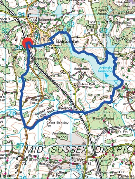
Walk 11 - Balcombe Circular
Distance: 7.5 miles / 12km
Grading = Moderate/Difficult
Location: OS Explorer map 135 (Ashdown Forest)
Start/End point:
Balcombe Railway Station (car park),
London Road, Balcombe RH17 6JQ
(daily charge)
- WAYMARKER 4 is on London Road by the pedestrian entrance to the station. Walk to the vehicle entrance to the car park on London Road and you will see the footpath to your right in the trees. Before you reach stile, take the left-hand turn to walk along the path adjacent to the road on your
- Ignore the big green public footpath sign and continue on along the side of the road and the footpath turns right through the trees.
- Go over a stile and then turn right downhill and follow the edge of the field until your reach a public footpath sign and kissing gate on your right that leads to some steps down to a bridge and into the woods and then up the hill on the other side which gets quite
- When you come out of the woods take the top track heading left. Just before the bend in the road on the right- hand side there is a stile signposted public footpath that goes down some steps to a little wooden bridge over a drainage gully. Go across the field, through another gate and follow the path down through the field ahead, keep the telegraph poles to your left.
- Go down some steps and turn left along the road, cross over and turn right to follow the footpath through the next field. The path comes out onto Cherry Lane, turn right over a wide stream and walk along this relatively quiet country lane with no pavement so beware of vehicles.
- When you reach the junction with the busy London Road, turn left and cross over to pick up the public footpath opposite and follow the track toward Great Bentley Farm.
- Go past some corrugated barns, the path turns to the right and on your left, before you reach the farmhouse, go through a metal gate, down some steps and walk straight on the higher ground with the hedge on your right.
- At the end of the field there is a bridge that goes over a stream, go over a stile, and then the path heads off diagonally left across the field.
- You have to go over another stile by a 5-bar gate, head diagonally right across the field toward and over a stile in the corner of the field. Go past a house on the right-hand side, the path turns left and then to the right through a kissing gate
- Go through the field toward the Ouse Valley Viaduct, through a kissing gate, through another gate and then under the viaduct (look to your right through the arches).
- Cross the field towards the road, go through a kissing gate and turn right to walk beside the road (take care as this is quite a busy road), cross the road, go over a bridge and pick up the footpath on the left. Go through a kissing gate and the footpath path runs along the side of the river on your left.
- At the footpath junction, turn left over the stream on a wooden bridge, cross another little bridge and follow the path up quite a steep hill with a hedge to your right.
- The path goes right through a gap in the hedge, follow the hedge on your right, the path goes to the left and you can see Ardingly College on the hill on the right. Go through a kissing gate and follow the path ahead to the footpath junction where you need to turn right and walk down toward Ardingly Reservoir.
- Go past the sailing clubhouse and slipway on your left and walk straight on to follow the path along the waters edge. Keep following this path until you reach Balcombe Lane where you turn left along the pavement until you reach a gate on your left.
- Head back on yourself with the reservoir on your left and keep following the bridleway until you come to Mill Lane where you should turn left. There is no pavement, the road turns sharply to the left so beware of oncoming traffic, then over the reservoir and snakes to the right past Mill Cottage on the left and Mill House on the right where a public footpath is signposted on the left up some steep steps.
- At the top of the steps head straight ahead up the hill, keeping the woodland to your right, toward the houses. Go past the houses on your left to reach Haywards Heath Road. Cross over and turn left to walk on the pavement for a short way and then turn right into Oldlands Avenue.
Turn right on Stockcroft Road if you want to go into Balcombe village for refreshments in the pub or the tea rooms.
- Walk on until you reach Newlands, the road curves round to the right and when you see a red postbox ahead you need to turn left, cross the road and follow the path toward Balcombe Station. Cross over London Road at the island and go in the pedestrian entrance (WAYMARKER 4), over a bridge and down the steps to the platform to return to the car park.
If you prefer you can download the walk guide to your phone.
Download the directions for Walk 11