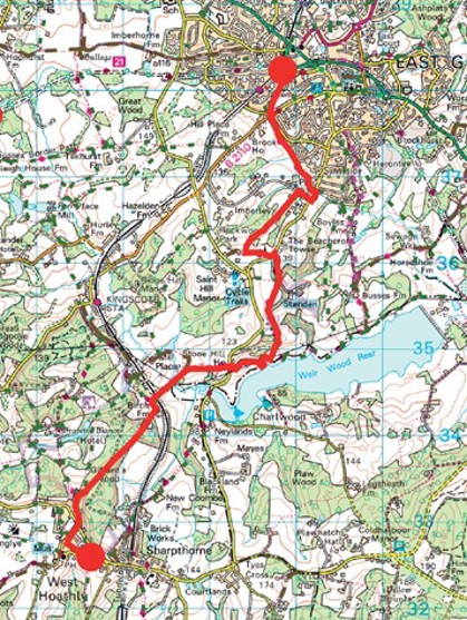
East Grinstead
Walk 6 - East Grinstead to West Hoathly
Distance: 6 miles / 10km
Grading: Moderate
Location: OS Explorer map 135 (Ashdown Forest)
Start point:
East Grinstead Railway Station Car Park,
Grosvenor Road RH19 1HS
End point:
Finche Field Recreation Ground (car park),
Church Hill, West Hoathly RH19 4PN
- Walk away from the station entrance (WAYMARKER 7) toward the roundabout, keeping Sainsbury’s on your right, and turn right down Brooklands Way. Pass Pannell Close on the left and continue straight on, past the park on your left to the junction at the bottom of the hill.
- Cross over at the roundabout and turn right into Turners Hill Road, and cross to the other side of the road. A few metres on the left-hand side there is a public footpath which runs behind the houses.
- Continue along this path through a number of gates, over a wooden plank bridge through a boggy patch and stream, past the housing to your left until you reach Streatfield Place, by the Dunning Mills pub.
- At the road, turn right and walk on the pavement for a short way, then turn right at Coombe Hill Road (marked Private Road), go past some houses and then turn left down Medway Drive into a large field with mature trees all around.
- Walk along the right edge of the field, through a wooden den and continue uphill on a sunken pathway with trees on either side. When you reach the rugby club, turn left and go past a mobile phone mast on your right to reach the road.
- Turn left at the road and then go right at the entrance to Standen House and Garden (National Trust), follow the track for a short way and then turn right onto a footpath just before the houses on your right-hand side.
- Walk down the narrow tree lined path, through a kissing gate into a cow pasture and continue downhill towards the reservoir with the field boundary on your left, go through a metal gate and follow the enclosed path through the trees, ignoring the footpaths to your right
Halfway Point (3 miles / 5 km): Weir Wood Reservoir Local Nature Reserve
- When you are nearly at the reservoir, turn diagonally right across an open field, cross under a power line, go through a gate and follow the fence around to the right until you come to a track with some metal gates on your left, with no public access.
- Turn right here, past the car park on your right-hand side and follow the track to the main road, then turn right up the hill.*Take great care at this point as it is a busy road.* A short way up on the left, there is a public bridleway sign and a metal gate, walk this way and go past the Stone Hill climbing rocks on your left.
- At the point where the main track bears right, follow a public footpath that turns left, through a gate into a sheep field, go straight across the field downhill toward a gap in the trees, past a stream and over a gated bridge on your right.
- Turn left and go over another little bridge and head for a gate on the far side of the field, with the vineyard to your right. Cross over the track, go through the metal gate into the woods and follow the path.
- Go over a stile and up a steep hill toward the Bluebell Railway line. At the top, Stop, Look, Listen and then cross over the tracks, go down the other side and over a stile at the bottom. Cross over a little wooden bridge and follow the path keeping the fence to your left until you reach a track.
- Turn left up the track toward Birch Farm, then turn right just before the white gates, to go over a stile and follow the public footpath straight on toward the woods. Go over a stile at the end of the field and walk through the woods on a wide path.
- Keep following the path straight on until you come to a wide track, turn left and then almost immediately right, to continue on the through the woods on a slight incline with some tall pine trees on the left. Cross over an unmarked track and continue uphill.
- When the path narrows you will reach a footpath junction, bear left on the path with banks either side and head uphill until you come to a gate and a kissing gate. Continue on, past Laburnum Cottage on your right and a garage on your left, toward West Hoathly village ahead.
- Take care crossing the road as there is limited visibility and then walk along the pavement on the right-hand side of North Lane. Walk past the recreation ground and public toilets on your right, and the primary school on your left, and then turn left onto Sandy Lane.
- Walk to the end and then take the path on the right past the garages, follow this path to the left of the Millennium Beacon, where you can take in the view toward the South Downs, and you will see the car park ahead (WAYMARKER 8).
If you are in need of refreshments, there are two pubs in West Hoathly – The Cat Inn, North Lane RH19 4PP and The Fox, Highbrook Lane RH19 4PJ
If you prefer you can download the walk guide to your phone.
Walk 13 - East Grinstead Circular
Distance: 6.5 miles / 10.5km
Grading = Moderate
Location: OS Explorer map 135 (Ashdown Forest)
Start/End point:
East Grinstead Railway Station, Railway Approach RH19 1EB
- Walk away from the station entrance (WAYMARKER 7) on the pavement toward the roundabout with Sainsbury’s on your right. Follow the signs for the Forest Way and cross over to reach Railway
- At the end of Railway Approach turn right and walk to the top of London Road on the right-hand side until the road bends to the right and you reach a belisha beacon crossing. Cross here and turn left down the High Street.
- Continue on the High Street past the War Memorial, Sackville College and the McIndoe sculpture to your left. Cross over Fairfield Road and walk straight on until you reach the Forest Way on your right; it is clearly signposted West Sussex Border Path and High Weald Landscape Trail.
- Follow the Forest Way straight down, cross over a residential road and continue on this wide tree lined path for some way. When you reach a brick bridge, go underneath and then turn right (to go back on yourself) and at the top, turn right to go over the bridge.
- Follow the tarmac road for short way until you see a footpath sign on the right, turn off the bridleway and follow the footpath slightly uphill through a field. At the top of the field go through a metal kissing gate and carry on the public footpath into the woods past some large rocks.
- The path goes under a little brick bridge and past a closeboard fence on the left. Continue on the path until you reach the main Lewes Road, turn left and cross over at the island, then pick up the Public Byway opposite, at the top of Hammerwood Road.
- The byway goes between a closeboard fence on the right and a wooded bank on the left, follow it downhill between the houses. When you reach a residential road, turn left until you see some high metal fencing, then turn left toward Cherry Garden Farm.
- Turn down the drive, through a wooden kissing gate to the right of the main gate and walk along the loose gravel track. Follow it up hill to the farmhouse and then take the right hand turn to follow a narrow public footpath which runs between a metal fence and a hedge.
- Keep following the path as it meanders through the woods and at the top of a slope you need to turn right through a wood and metal kissing The path goes downhill through the woods, the path turns to the left, past some big redwoods on the right.
- When you reach a wooden log bench, turn right. The path skirts round Fowl Wood and when it bears right you need to turn left over a stile, keep left and walk downhill. You will see a solar farm through the trees on your left-hand side.
- Go over a wooden plank bridge, keep following the public footpath through the trees then go over a stream on another wooden bridge. Walk into an open field, the path goes straight on between two metal fences. At the top of the field go through a kissing gate, walk on with the hedgerow on your left and a metal fence on your right.
- Go through a metal gate and follow the narrow path between a closeboard fence and hedgerow (mind the overgrown holly bush!). When you reach Fairlight Farm bear right up a farmyard track, past some barns. Just past Fairlight Cottage, turn left to follow the public footpath signposted West Sussex Border Path.
- The path goes downhill toward Ashplatts Wood. Continue on the West Sussex Border Path until you see a green arrow directing you to turn right to follow a woodland trail. Go over a wooden bridge over a little stream and then over another little bridge, keep following the green arrows until you reach the East Court recreation ground.
- Turn left and walk round the edge of the playing fields with the woods on your left, you can see a large mansion house in the distance on your right (East Grinstead Town Council offices). At the end of the playing fields the green woodland trail turns left, by the dog waste bin, over a wooden plank walkway and then turn right.
- The path winds through a wooded area then continue on the narrow Sussex Border Path. The path goes slightly uphill, past a pond on the right there are residential gardens to your right. You will come out onto a tarmac road by some pretty cottages and Estcots farmhouse, walk straight ahead then cross over the road and turn left toward Estcots Drive.
- Cross over Estcots Drive at the island, walk over the bridge and cross over at the pedestrian crossing, then turn back on yourself over the bridge and go left down Sandy Lane. This quiet road runs alongside the railway cutting to your left, now the A22 Beeching Way, and there is no pavement so be aware of vehicles.
- At the bend, turn left to take the footbridge over the main road. Turn left, then cross over at the junction and go right on the pavement with King Street car park on your right. Walk on past the public toilets on your right toward London Road, cross over at the pedestrian crossing ad then turn right.
- At the mini roundabout at the bottom of London Road, turn left onto Railway Approach. Follow the road back to the roundabout to return to the East Grinstead station forecourt (WAYMARKER 7)
If you prefer you can download the walk guide to your phone.